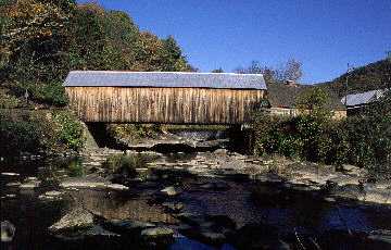
Tunbridge's Mill Bridge (as it was before March 1999)
from Spanning Time: Tour 11 - The Northern Tributaries of the White River¹
The Mill Bridge serves a busy road in the middle of Tunbridge village, just west of Route 110. Name boards on each gable proclaim "Mill Bridge - 1883," and another sign promises a "One dollar fine for a person to drive a horse or other beast faster than a walk or drive more than one loaded team at the same time on this bridge."
The bridge, also known as the Hayward and Noble Bridge, uses the multiple-kingpost truss. The dam belonging to the mill that named the seventy-two-foot structure still stands upstream. The waters of the First Branch spill over the dam, flow over bedrock, then pass under the bridge. The bucket of flowers so common to the area stands out front.
The Vermont Division of Historic Sites described the surroundings when nominating the bridge for the National Register of Historic Places: "The bridge stands next to the 19th century mill district of the village. Together with an upstream dam and pond, the covered bridge and the mill buildings make an exceptionally attractive and functional historic element."
Photographic evidence from the 1870s indicates that an open bridge served at this location before it was replaced by the present covered bridge. The house at the west approach has changed little in outward appearance since then. The brick building beside the bridge was a black smith shop, first established in 1791.
The first bridge at the site was built in 1797 and destroyed by flood the following year. The replacement bridge served until 1815 and was followed by a third. The dam above the bridge ran a grist mill.
To read more about the area and its bridges, check out A Pictorial History of Tunbridge, Vermont, by Euclid Farnham.
Listed on National Register of Historic Sites as Mill Covered Bridge 7/30/1974
| Build Date: | Truss Type: | Truss Length: | Truss W/H: | Overall Length: | Builder: | Location: | Stream: | Orientation: | Status/Cap: | Deck Girders: |
| 1883 | Multiple Kingpost | 72 feet | 15'6"/12' | 78 feet | Unknown* | Tunbridge | White R.1st Br. | NW-SE | In use/ 8T | No |
VAOT #5. Other name(s): Hayward and Noble Bridge. Stands below mill dam in village mill district.
*Arthur Adams per Euclid Farnham, Tunbridge historian.
[World Guide To Covered Bridges Number: VT-09-09]
1. Spanning Time Vermont's Covered Bridges by Joseph C. Nelson ©1997