LYNDON — The Sanborn Covered Bridge could be rebuilt on land rather than returned to its original crossing over the Passumpsic River, a contractor told the Select Board on Monday.
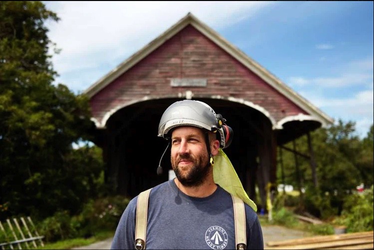
Miles Jenness of Huntington-based Vermont Heavy Timber said it was feasible to reassemble and mount the historic span on land, with work potentially completed by next summer at an estimated cost of $400,000 to $450,000.
Jenness, whose company removed the bridge from the river in August 2024 as a precaution ahead of Tropical Storm Debby, advocated for the town to preserve the iconic structure — one of the last remaining Paddleford truss style covered bridges in the country.
“I really love this bridge. I was really hoping to get the job to restore it [over the river]. I’m sure many of you are saddened to hear that that part of the project fell through. But I would love to restore it in any way,” he said.
The Select Board took no action, citing the need for more detailed cost estimates and a clearer understanding of available funding. Board members said public input will be sought at their May 4 meeting.
During discussion, Jenness said the 157-year-old bridge could be rebuilt on the same town-owned Main Street parcel where it is currently stored in pieces.
He proposed mounting the structure on concrete footers and adding ramps for pedestrian access. He also said the bridge could be restored to a condition that would allow it to be moved back over the river in the future if circumstances change.
“What I’d love to do is rebuild it as designed to be a clear span. I’d love to see it go back over the river,” he said.
Shift follows collapse of river restoration plan
Earlier this month, town officials announced that plans to return the 157-year-old bridge to its river crossing had been abandoned, ending a five-year restoration effort.
Officials said the project could not move forward due to a combination of factors, including the inability to secure a key easement, the need for Act 250 approval, delays tied to major flooding and federal disaster recovery work, and grant timelines that have expired.
The town had secured about $2 million for the restoration, including $100,000 in American Rescue Plan Act funds, nearly $100,000 in private donations and about $1.67 million in federal grants and earmarks.
Funding sources included congressional directed spending, the Northern Border Regional Commission, the VTrans’ Transportation Alternatives Program, U.S. Department of Agriculture grants, the Freeman Foundation, the Vermont Housing and Conservation Board, the Paul Bruhn Historic Revitalization Grant and the Vermont Division for Historic Preservation.
Grant deadlines have already forced the town to return the $100,000 Paul Bruhn grant. Because the bridge will no longer span the river, the project also no longer qualifies for the $300,000 Transportation Alternatives grant.
Town officials said about $550,000 has already been spent, including emergency removal of the bridge ahead of Tropical Storm Debby in 2024 and engineering work. They do not expect to have to repay those funds.
Project manager Nicole Gratton said a mix of private donations, the Freeman Foundation grant, ARPA funds and part of a covered bridge endowment remain available for the project — in whatever form it takes.
“All in all there is between $350,000-$400,000 to support a next life for the bridge without the use of federal funding,” Gratton said.
Flooding, redesign and permitting challenges
Plans to restore the bridge were already underway when three flood events in 2023 and 2024 received federal disaster declarations, requiring extensive cleanup, repairs and federal reimbursement work that slowed progress on the Sanborn Bridge.
One of those floods caused significant damage to the bridge, leading to its emergency removal in 2024.
Afterward, consultants with SLR International identified the bridge abutments as a major contributor to flooding in the north end of town. That prompted the town’s Hazard Mitigation Committee to request a redesign.
“We hired an engineer that led to the conclusion of the Sanborn bridge abutment being a major factor in what holds the water back at the north end of town,” Town Administrator Justin Smith said earlier this month.
The revised design raised the bridge above the 500-year flood level, redesigned its abutments and improved water flow. Those changes required a larger project footprint and additional property access, necessitating a new easement that the town was unable to secure after nearly two years.
At the same time, the project faced a new regulatory hurdle.
In a Feb. 3 jurisdictional opinion, state officials ruled that reconstruction would require an Act 250 permit, finding the revised project represented a “material change” tied to development review at the former Lyn-Burke Motel property.
The opinion said the bridge project could have “a significant impact” on river management plans associated with a proposed gas station and mini-mart at the site.
Officials said the findings highlighted a broader conflict between historic preservation and public safety.
“You have two worthy goals. You want to see the Sanborn bridge back over the river, but you have a science-based engineering report that says that that’s the cause of a lot of the restriction of flow of water… and you’re talking about other properties, damage to buildings, possibly… risk to human life,” Smith said.
Covered bridge history in Lyndon
Built in 1869 and moved to its current location over the Passumpsic River in 1960, the Sanborn Covered Bridge was purchased by the town in 2022 along with a two-acre parcel on the south end. It is one of just two Paddleford truss bridges in Vermont.
Lyndon is often referred to as the “Covered Bridge Capital of the Northeast Kingdom,” with several historic spans still standing across the town.
The Millers Run Bridge, dating to the 1800s, connects Lyndon Center and Route 122. It carries one-way traffic and includes a covered pedestrian walkway and is the last covered bridge used in the state highway system.
The Randall Bridge, built in 1865 just north of Lyndonville, once carried traffic over the East Branch of the Passumpsic River. It was replaced in 1965 by a concrete bridge but remains standing for preservation.
The Chamberlain Mill Bridge, built in 1881, spans Branch Brook and connects York Street and South Wheelock Road in Lyndon Corner.
The School House Bridge, built in 1879, is located at the junction of U.S. Route 5 and South Wheelock Road.
Our thanks to the Caledonian Record for permission to reprint this article